
California Dreaming, Part Two
- dougsmith51
- Apr 6, 2024
- 7 min read
NOTE: This is the 2nd of a two-part blog story about our time in California. It's on the long side because there is so much to report. Click here to find the first California blog post.
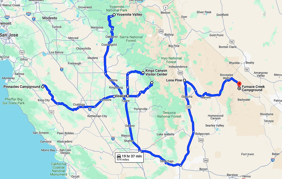
We left the campground at Pinnacles National Park on March 7th and drove to Visalia, CA. It would serve as a jumping off point for visits to several national parks. Visalia is located in the central valley of California, and is surrounded by huge warehouses and, further out, many, many orchards.
We first drove to Sequoia National Park. Although it was 60-70 degrees in Visalia, the temperature cooled as we entered the park and drove uphill to see the sequoia groves. We could see snow on the peaks of the Sierra Nevada mountains, which had gotten 7-10 feet of snow in a powerful storm a few days before. Mt. Whitney, the highest peak in the continental U.S. is located in Sequoia NP, but can only be seen from the eastern side of the range.


By the time we reached the sequoias, at 6,000 feet in elevation, there was about two-feet of snow on the ground. Fortunately, the National Park Service is good about trying to keep the road clear, although a number of the park's major sites (including the portion of highway between Sequoia and Kings Canyon National Park) are inaccessible till later in the spring.


We hiked in the Giants Grove along a trail where massive sequoias surround a meadow. The meadow itself is too damp for the sequoias although, with their massive needs for water, their roots tap the meadow's aquifer.


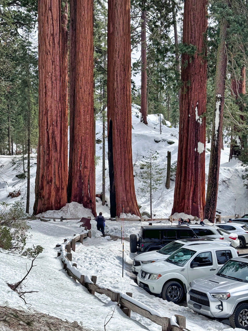
Sequoias are not the tallest trees in the world (redwoods are) but they are much more massive and thus the largest. You still have to crane your neck to see the tops.
Here are some size comparisons:

Just up the road from the Giants Grove we visited the General Sherman tree, the largest living thing on earth.

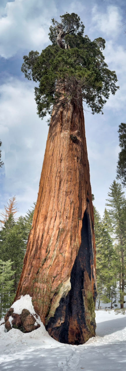
One interesting fact about sequoias: they are pretty fire resistant, especially the mature giants with super thick bark protecting the living part of the tree that lifts nutrients to the top. Fire is actually part of its life-cycle - cones won't release their seeds unless they've been through a fire. You can see many sequoias that have fire scars. Over many decades the bark grows to re-cover the scar.

We drove back to Visalia, and the next day drove to Kings Canyon National Park. Most of the park is closed in the winter, including the massive canyon that gives the park its name. However, we were able to drive to Grant Village, home to another sequoia grove. Grant Village is at an even higher elevation, 7,000 feet, and the visitor center was buried in snow.

We drove to the parking lot for the Grant Grove.

The most famous sequoia in Grant Grove is the General Grant tree. Not quite as massive as the General Sherman, but still huge!
We drove down about 2,000 feet in elevation and hiked around Hume Lake. A manmade reservoir, it has a very interesting dam structure built in 1908.


Before leaving the park, we drove back up and beyond the visitor center to see a view across (but not into) Kings Canyon to the High Sierra beyond.

The road to the viewpoint passed by Redwood Mountain, a protected grove (no roads) with the most number of sequoias on earth (over 2,000). The world's tallest sequoia, 316 feet, is in that grove.

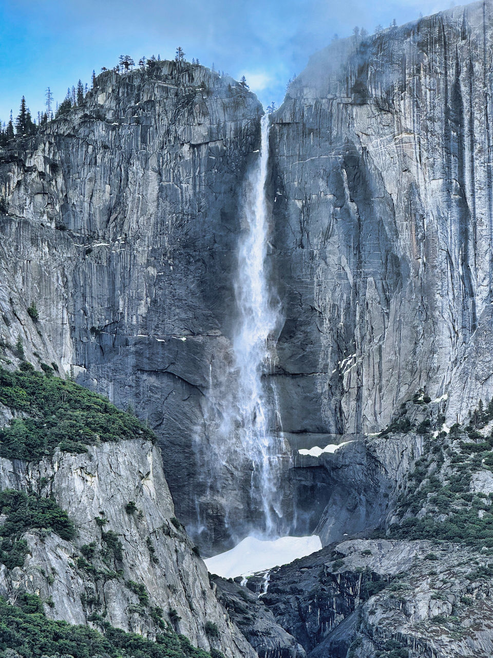
We returned to Visalia. The next morning, we left the Ciaowagen at the campground, and drove three hours north to Yosemite Valley, one of the few portions of Yosemite National Park open year-round. We arrived a few days after a winter storm had dumped 7-10 feet of snow in the High Sierra, although the few inches of snow that had accumulated in the Valley had melted by the time we arrived. We'd booked a room for two nights at the Yosemite Valley Lodge, since only one campground (with dry-camping sites too small for the Ciaowagen) was open this time of year. We arrived to dramatic views of clearing clouds.

We drove up to an overlook of the valley (it's at the end of a tunnel that visitors coming from the south drive to). Fortunately, there were not many visitors mid-week in the middle of the winter, so we were able to find a parking spot and join the other onlookers.


We drove down to the valley floor, with dramatic views of the cliffs and waterfalls.


After checking into our room, we walked to the visitor center and back, and then drove to the base of Bridalveil Falls (the falls you see from the tunnel view). In winter, the falls are not as full as during the spring melt, but are still quite impressive.
The next morning, we walked to Yosemite Falls, located near the lodge. Taken together, the lower and upper falls are the highest in America.

We could see frozen ice on the cliffs on either side of the falls. Also, during the winter a hill of ice accumulates at the bottom of the upper falls. It can grow to a height of 60 feet or more.
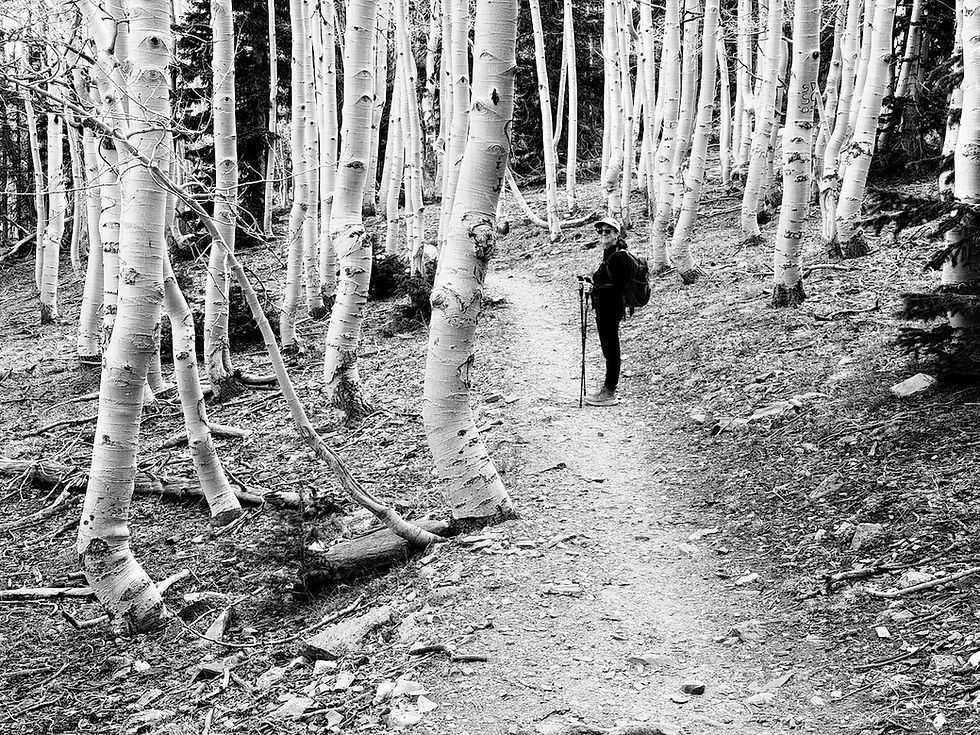
The valley floor has both meadows and forests, allowing us to feed our tree-hugger habit. We could also see new growth in areas where the tree canopy allowed the sun to peek through to the ground.


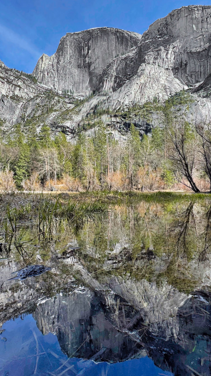
Later that afternoon, we hiked to Mirror Lake, a widening of Tuolumne Creek which sits directly below Half Dome. The reflections were awesome in the relatively still waters.

As we walked back to our lodgings, we passed the iconic (and expensive) Ahwanee Hotel.

Our last day in the park was a windy one. As we packed up the car, we could see how Upper Yosemite Falls was being blown to the side.

We left Yosemite Valley and drove north to the Hetch-Hetchy area of the park. Crossing over a ridgeline, we again encountered snow. We also had a chance to see one of the machines they use to try to keep the roads clear. It looked like an industrial strength snow thrower combined with a chain saw.

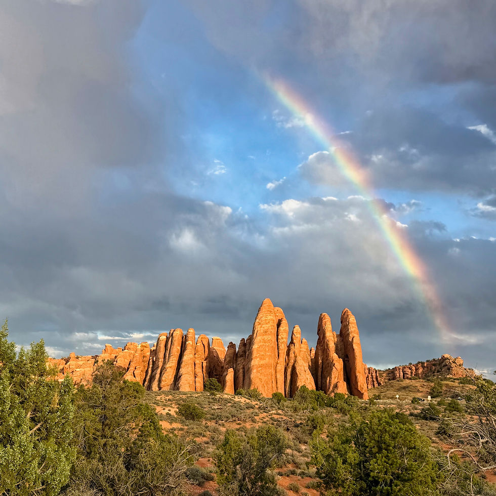
Hetch-Hetchy was once a valley that rivaled Yosemite Valley in majesty and beauty. It was dammed (to considerable controversy) in the 1920s to provide a reliable water supply for San Francisco after the Great Earthquake. The reservoir is impressive, but you wonder what now lies hidden beneath.

The reservoir was full after the recent winter storms, and the dam's floodgates were open, causing a beautiful rainbow.

There are hiking trails along the sides of the reservoir, including one to a thousand-foot waterfall that can be seen in the photos above. We walked to the entrance of a long tunnel that leads to the trails and peered inside, but did not proceed further because of time pressures and the severe wind.


We returned to Visalia for the night, and the next day departed for the small town of Lone Pine, California on the eastern side of the Sierras. We needed to drive all the way around the mountains on the southern side to reach it, since no roads cross the peaks.
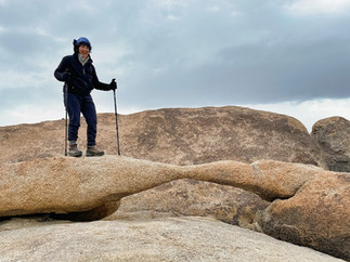
Our objective in staying overnight was to visit the Alabama Hills, an area of stacked, rounded boulders that sit below Mount Whitney. We could not see Whitney's summit, but were able to make out some mountains that stand near it.


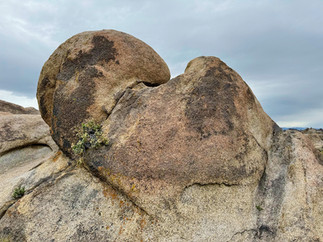


We hiked the Arches Trail which led to interesting rock formations, including a small two-foot-high arch and aptly-named Mobius Arch.


We continued eastward to enter Death Valley National Park, one of the largest in the Lower 48 states. It's more than 140 miles long, and even from the height of the Dante's View overlook some 4,000 feet above the valley (and about in the middle of the park north-to-south) you still cannot make out the end.

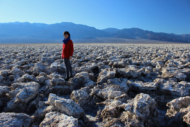
This winter, water from the atmospheric rivers that drenched California made it as far inland as Death Valley, forming temporary Lake Manly in an area that is normally just salt flats, as you can see in the two pictures below from a past visit.


The temperature was moderate in the springtime.

We'd been to Death Valley twice before (in 2006 and 2016, plus a quick Ciaowagen drive-through in 2019). Our 2006 summer visit had a very different temperature profile.

We checked into the Furnace Creek campground located in the heart of the park. The next day, we had the opportunity to visit Lake Manly, located in the Badwater Basin area of the park, the lowest point in the United States.


Normally, Badwater Basin has just a small shallow pond, like this:

Not so this year, with Lake Manly covering nearly five square miles.

A month before, the lake had been deep enough that people brought their kayaks! By the time of our arrival, the lake had shrunk enough and lost so much depth that the Park Service had posted "no boating" signs.

This did not stop the many people that wanted to wade in the lake.


We did not wade ourselves, but our hiking boots were still crusted with salt as we left the area.

Death Valley has a number of beautiful hiking trails, and we spent a morning hiking the Golden Canyon Trail, which leads up to a dramatic formation called the Red Cathedral.


Although the rock has different colors most of it is limestone, created when this area was a shallow sea during the Jurassic era. The rock is relatively crumbly.
Nearby is the scenic overlook of Zabriskie Point, where you can look down on that same badlands geography.


On our final full day in the park, we rented a jeep so we could explore the back country.

We'd been hoping for a spring superbloom in Death Valley. There were some flowers, but not many. We learned that superblooms only occur about once a decade, and only under particular conditions (atmospheric rivers and windstorms do not help).

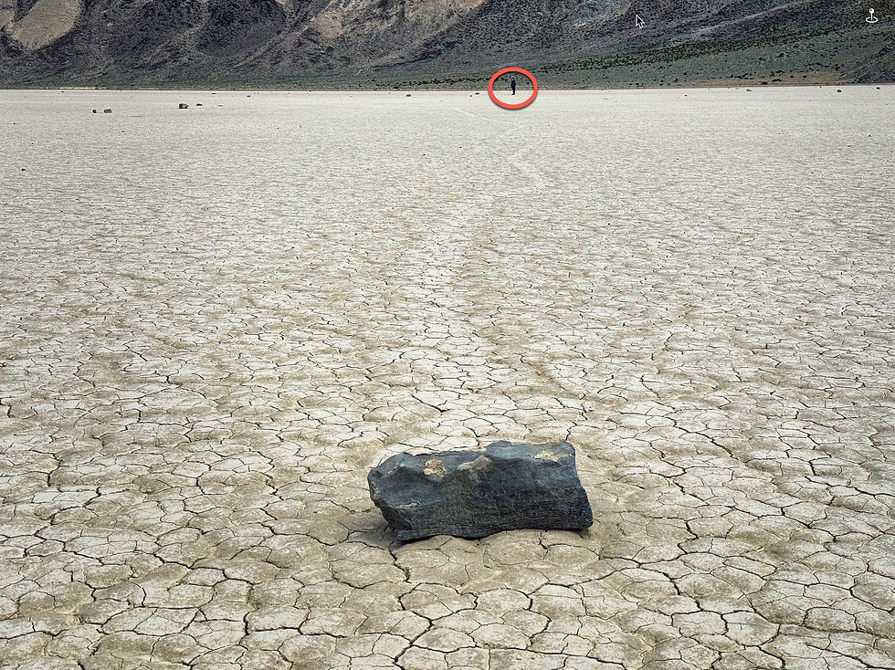
Our main objective was to reach the Racetrack Playa, a dried lakebed in a hidden valley that takes 2-3 hours of driving to reach. On the way, you pass the aptly named Teakettle Junction, decorated by visitors over the years.

The playa is one of the flattest places on earth, with only a two inch difference in height over the whole lakebed. The dried mud is at least 1,000 feet thick.

At the north end of the playa is a stone formation called The Grandstand.


Racetrack Playa's main claims to fame are its mysterious "sailing stones" that lie on the southern end of the lakebed.

Trackways clearly show that the stones move on the lakebed, often for considerable distances and on winding tracks. For many years, how this happened was a mystery, but scientific studies in the last few years revealed the secret.


After our visit to the Racetrack and return to Furnace Creek, there was enough sunlight left to explore another backcountry area, the winding Echo Canyon...

...which leads to the historic Inyo Mine. Gold, silver, and borax mining claims were located in the Death Valley area before it became a national park.

Whew, we know that was a lot to digest, but California's wonders are many and we wanted to share them with you! It was time for us to head east again, toward Texas and the 2024 eclipse. It would take us over 1,000 driving miles to get there - more about that journey in our next blog post.

Comments