
Great Basin And The Sawtooths
- dougsmith51
- 1 day ago
- 8 min read

Baker
We left Moab for Baker on Thursday, May 21. As Moab sits close to the Utah-Colorado border, we headed pretty much due west for 330 miles, crossing the entire state. Baker is just over the Nevada border, and we moved into Pacific Daylight Time for a few days. The last 50-60 miles of the drive was through empty desert - just sagebrush, salt flats, sand, and a whole lot of nuthin'. The town of Baker is quite small, with a campground, a motel, a general store, a gas station, and one of the two visitor centers for Great Basin National Park.

The Great Basin is one of four American deserts (the others are the Sonoran, the Chihuahuan, and the Mojave), and is the only "cold desert" (due to its elevation above 6,000 feet). It occupies most of Nevada, and parts of California, Utah, idaho, Wyoming, and Oregon. All the rain that falls on the Basin (less than 10 inches per year) drains into the Basin rather than to the Gulf or one of the oceans.

The national park preserves just a small, pristine area of the Great Basin, and centers around Wheeler Peak.
Great Basin National Park

We'd been to Great Basin National Park once before, in September 2020 during our COVID trip. Leading up to our 2026 visit and looking at the NPS website, we were fearful that most of the park would be closed by snow, but they managed to open everything for Memorial Day weekend, just in time for our arrival. The park is never crowded, ranking 54th out of the 63 national parks in terms of visitation, with just 161,000 visitors per year. This is likely due to its isolation, because Great Basin National Park is spectacular and well worth seeing!
On our first day, we drove up the 13-mile-long Wheeler Peak Scenic Drive, which took us from 6,500 feet elevation to over 10,000, and through several different plant zones. As we climbed, we could look out to the vast empty desert flats below and mountains more than 50 miles in the distance.

The drive brought us closer and closer to Wheeler Peak, which still had some snow and, hidden under tha snow and some rocks, Nevada's only glacier.

We noticed at one of the overlooks how the Park Service had modified a railing to accommodate a rugged tree. That's taking care of Mother Earth in action!


We reached the end of the drive, parked, and hiked the short Island Forest Nature Trail. It was beautiful, and a snow-fed stream coursed down beside us. Because of the high elevation, the aspen trees were not yet blooming along that trail.


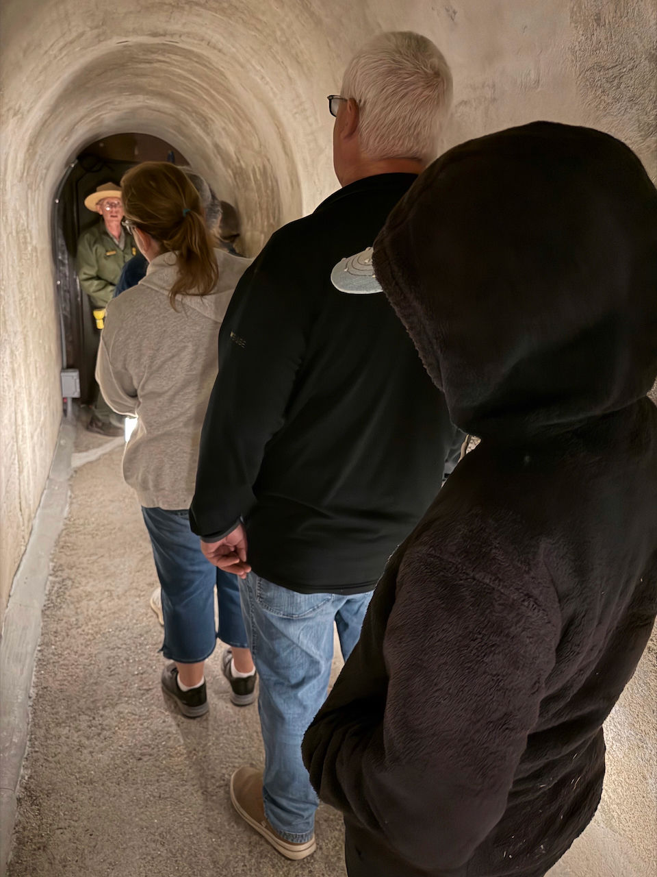
We then headed downhill for our 3:30 tour of the Lehman Cave, one of the park's more famous sites. The Cave was protected first in the 1930s. Great Basin was not made a national park until the 1980s.
The Park Service is in the middle of replacing the lighting system within the cave, and had literally re-opened for limited tours that day. We were able to visit two rooms of the caves on a lantern tour. Before heading into the cave, we had to walk through a disinfectant solution to guard against transferring white-nose syndrome to the bats who live in the cave.

We then walked through a concrete tunnel into the cave proper.

The two cave rooms we visited were small but full of beautiful formations of many varieties: stalactites, stalagmites, columns, popcorn, and round shields. Unlike many caves, the rock was marble rather than limestone (limestone morphs into marble under high pressure and temperature), and we learned that these are the geologically oldest caves in the U.S.


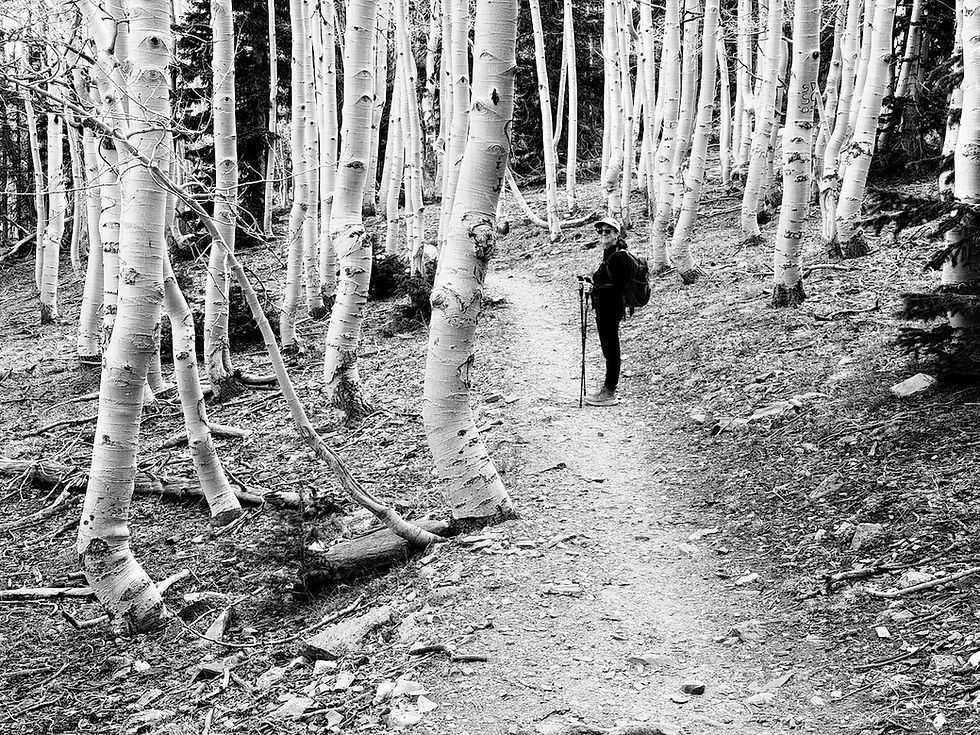
A couple of days later, we drove back up the Wheeler Peak drive, parked, and hiked the 2.6 mile round trip to Stella Lake. The trail is all above 10,000 feet. Fortunately, we'd been camping at higher altitudes for 5-6 weeks so we did not have to huff and puff on the trail. The aspen trees along this trail were just starting to get their leaves.


We saw a group of mule deer browsing in a meadow. Hikers we talked to said they'd seen a flock of wild turkeys in the same meadow earlier in the day.

Finally, we came upon beautiful Stella Lake. There were some other people there, including kids skipping stones on the water.

We found a bench and basked in the sun. We pulled out a few snacks to munch on, and a chipmunk came up to us to investigate (and beg). We resisted. One of the things we've learned from park rangers over the years is that "a fed animal is a dead animal."

That evening we came back into the park for the ranger program. Since Great Basin is a Dark Sky Park, the topic is usually astronomy-related. This evening it was about exoplanets (planets outside of our solar system). Red lights (easier on the eyes for adjusting to the darkness) led us to and from the amphitheater, and after the ranger talk telescopes were available for night viewing.


During our 2020 visit to Great Basin, we'd hiked up to see a grove of bristlecone pines. These were older (and in much better shape) than the bristlecones we'd seen at Bryce Canyon. Unfortunately, there was still snow on that trail so we weren't able to make a 2026 visit.

Interestingly, we learned that some aspen groves may be older than the bristlecones. This is because aspens grow primarily by cloning, with underground roots propagating new trees. This is one of the reasons you see aspen groves with trees growing close together.
On our last full day in the park, we drove a few back roads, and hiked a portion of the Osceola Ditch Trail which followed the path of an aqueduct built in the 1800s to carry water from mountain streams to a gold mining operation in the valley. Only pieces of wood used to construct flumes were left, and the trail was a bit too rocky for our taste - we spent more time picking out how to navigate the rocky terrain and looking at our feet than looking at the scenery.


Ely
On the evening of our first full day in Baker, we drove about an hour to the town of Ely, an old mining community at the intersection of three major roads. The Northern Nevada Railway Museum is located there, and they offer a variety of train trips into the nearby countryside. We had signed up for the Star Train, offered once every two weeks, which has an astronomy-based theme. We boarded the train around sunset.


We were each given a light-up Star Train pin.

The train then traveled slowly about 10 miles out of Ely. The engine switched to the other end of the train, and about halfway back we stopped at an area where four telescopes had been set up. The group rotated through the telescopes, after which the astronomers would switch viewing to a different object. We had three rotations overall: (1) Jupiter and its four Galilean moons; (2) the M-13 globular cluster in the constellation Hercules; and (3) a binary star pair where one was yellow and the other blue.


Stanley
It was time to move on again. We were still only about a third of the way between the U.S. southern and northern borders, so we had two long driving days to get from Nevado into Idaho and up to the Sawtooth mountains. We left Baker on May 26 and overnighted in the town of Jerome, just north of Twin Falls, staying at an RV spot at the Snake River Elk Lodge. We also moved back into Mountain Daylight Time.
The Sawtooth Range
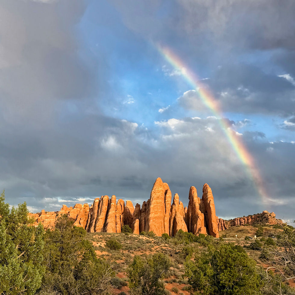
We had visited the Sawtooths once before in August 2020, going there because we heard how beautiful the mountain range was. When we arrived back then there was strong smoke from California wildfires, we could barely see the mountains, and the sunsets were blood red.


We'd always wanted to come back when the conditions were clearer. Thankfully, they were!

Click on the photo above to select it, then Zoom in and look at the ragged ridge-lines of the mountains. You can easily see how the Sawtooths got their name.
We were also impressed with how much snow was left on the mountains at the end of May. We learned that Stanley can be one of the coldest places in the U.S., and that may explain the late melting.
Stanley's year-round population was small when we visited in 2020, but it's boomed by 86 percent, from 63 to 117!


We stayed in the small Mountain View RV campground (6 sites), which is associated with the Mountain View Lodge which also operates the Mountain View Restaurant and the Mountain View Mercantile Exchange (the town's grocery and souvenir shop) and the Mountain View gas station. Despite the town's small size, Stanley does have an excellent food scene and we ate out at a few different restaurants during our stay.
We did several hikes while we were in the Stanley area. One was along the shoreline of Redfish Lake, carved by glaciers during the Ice Age, and now part of a National Recreation Area managed by the U.S. Forest Service.

On the drive to Redfish Lake from Stanley, you pass along the Salmon River.

At Redfish Lake there are several campgrounds, and a lodge with cabins where people can stay.

We hiked the paved trail alongside the lake.


The next day, we drove to Stanley Lake, which sits on the other side of the mountains. There was a trail (unpaved, this time) that went along the lake shoreline.


Wildfires burned some of the area in 2024, and portions of the trail had been destroyed and were not yet rebuilt.

We saw beautiful small wildflowers along the way.


At one point, the trail became a bit flooded, and we had to carefully make our way across on some logs.

As we looked closer, we could see that beavers had been busily at work, raising the water level and causing the flooding.


In the evening, after a delicious dinner at one of Stanley's restaurants, we took advantage of a private hot spring maintained by the Mountain View company.

It was cloudy out, but we had wonderful views of the mountains.

As we were leaving, the clouds began to dissipate and the horizon glowed pink.

The next day we hiked about four miles on the Redfish-to-Stanley Trail. It's an accessible trail, similar to a rail-trail (except there was never a railroad here). It was so peaceful listening to streams running nearby and birdsong, and breathing in the fresh mountain air!


One of the things we learned during our stay in Stanley was that the "season" doesn't really start until mid-June and ends in early September. Perhaps that's due to the cold weather here.


Leaving Stanley on June 2nd, we drove the Ciaowagen to Boise. We need to fly home for 10 days for a family reunion and a family wedding, and picked a campground near the Boise airport. The RV will stay plugged in so the food in the refrigerator doesn't spoil.
Upon returning from home, we'll move on to Yellowstone and Grand Teton National Parks. More about that in our next blog post, likely to drop around the end of June.


Comments