
The 3 M's: Moab, Monument Valley, Mesa Verde

After a great month exploring Colorado, we moved back into Utah on August 31.
Moab
We arrived in Moab for our second visit during this 2026 trip. It was good timing for two reasons: (1) Moab, which is notoriously hot during the summer, was experiencing mild temperatures in the 80s; and (2) since many kids were back in school, we arrived after the summer crush and the town and nearby parks were uncrowded.
We'd also come back hoping to do some activities we'd missed during our Moab time in May.
On our first full day in the area, we drove into Arches National Park. They'd abandoned their timed-entry permit system for 2026, so we weren't sure what we'd find, but when we arrived at the entrance gate there was only one car in front of us. We drove past many of the pulloffs and grabbed a parking spot at the trailhead for Delicate Arch, the most iconic of arches in the park and on every Utah license plate.

We hadn't attempted the Delicate Arch hike back in May, but with our acclimation to higher elevations and our renewed confidence after taking on more difficult (for us) hikes in Rocky Mountain National Park, we decided to give it a try. The trail is about 3.5 miles round trip, climbing up some 650 vertical feet. More than half of that is up a long slickrock slope.

While there were other people on the trail with us, it was not crowded. Having other people was helpful in following the trail through several twists and turns toward the end. The trail is not technically challenging but it's exposed to the sun the whole way, so we made sure to bring plenty of water with us.
The last part of the trail follows a narrow ledge...

...and then you suddenly come upon Delicate Arch. One of the things that makes the arch remarkable is that it sits, by itself, on the edge of a rock platform.

During our last visit to Delicate Arch (in 2021) we'd gone at sunset and it had been super-crowded. This time, there were just a few other hikers there.
We got close to the arch for a few Instagram-worthy photos (although we don't post on Instagram).

By the time we got back to the car we were tired enough to call it a day.

The next day we drove to Dead Horse Point State Park, which offers beautiful views of Colorado River canyons below from its high perch on a mesa. When we'd visited in May, the wind was blowing 50-60 mph which made any hiking challenging. This time, there was no wind (and hardly any visitors) as we hiked 2 miles along the East Rim of the park taking in the views.
On our final full day in Moab, we signed up for a UTV (Utility Terrain Vehicle) off-road guided trip through some of the slickrock courses that make Moab at UTV mecca. We went with Moab Tour Company, the same company we'd rented from for our off-road Jeep tour of Canyonlands NP in May. There were six vehicles in our caravan, plus a leader and a follower from MTC.
We'd never been UTVing before, but they operate pretty much like a car so the skills were easy to pick up. The main difference is driving up and down rock walls at steep angles, as much as 60 degrees (thank goodness for sticky tires) plus height and suspension for climbing over rocks and boulders on the way.

After driving through town, we went to a UTV course called "Fins and Things" to build up our skills and feel comfortable that we could drive slopes without flipping over. Then it was on to the main event, a 6.5-mile-long world-famous course called "Hell's Revenge." A bit stomach-churning at times, but fun overall.

Now we can say "been there, done that." No need to repeat the experience.
While on the trail, we befriended a lovely Italian couple, two lawyers on their honeymoon, Guilia and Alberto. We had dinner together later that evening at a Thai restaurant in downtown Moab.
Monument Valley
Then it was on to the iconic Monument Valley, whichs straddles the Utah/Arizona border. On our drive south we passed through the town of Mexican Hat, UT. This nearby rock formation gives the town its name.

As we got closer, we passed slowly through the crowds of people determined to get their Instagram photo at "Forrest Gump Point."


We'd been to Monument Valley a few times before: once when Jeannette was pregnant with our son Mace in 1991, another time with Doug's Mom in the late '90s, and a third time in 2021 while traveling in the Ciaowagen. On our first full day in the area, we signed up for an all-day guided tour. There were six of us riding in the back of an open-air truck, plus our Navajo guide Chandler.

You can drive through Monument Valley on your own, but the sights you see are limited. One of those is called John Ford Point, after the director who filmed several westerns in the area.
Going on a guided tour takes you to backcountry areas you would not normally be able to see, including a number of arches, rock windows, and petroglyphs.
We also stopped by a hogan (a traditional Navajo living structure) where an older woman was carting wool and pulling it into yarn.
There was also a special moment where Chandler played a native flute for us in a rock overhang that amplified the sound.

After a quick lunch, Chandler drove us a few miles south of Monument Valley to another area called Mystery Valley. There we saw a few more arches and also the ruins of some cliff dwellings made by Ancestral Puebloans.


On our second day in the area, we drove about an hour north (back into Utah) to Natural Bridges National Monument. Natural Bridges sits atop a large mesa, and Google Maps led us up a fairly precipitous dirt road climbing 2,000 feet.
In the national monument there are three large natural bridges formed as meandering streams broke down and through rock walls. You can see the bridges from overlooks from the park road. There are also a number of smaller bridges in the park, although we did not see them from the scenic drive through the park.


We hiked downhill at the third (and oldest) bridge, Owachomo Bridge, to see it up-close-and-personal.


An interesting side note about the desert life in this area. Much of the "sand" is actually covered by a thin crust of cryobacteria, fungus, and algae. This crust is key to helping desert plants thrive in the area. The mats can take decades to form, but can be destroyed in an instant by a footprint. This is why it's important to pay attention to those "Stick to the Trail" signs.

Mesa Verde
We headed east back into Colorado the next day to settle in at Mesa Verde National Park. When were last in the park in 2020, you could not visit any of the cliff dwellings because of COVID. This time here were no restrictions. We camped at Morefield Campground right in the national park.
Mesa Verde is a large park - it can take 90 minutes of driving up and around the mesa tops to get from the entrance to some of the sites. The mesa was occupied by Ancestral Puebloans from about 450 to 1300 A.D. Most of that time, people lived and farmed on top of the mesa. First, they lived in pithouses dug into shallow ground. Then they began building multi-room and multi-story buildings. There's a loop drive where you can visit older sites and see the progression.

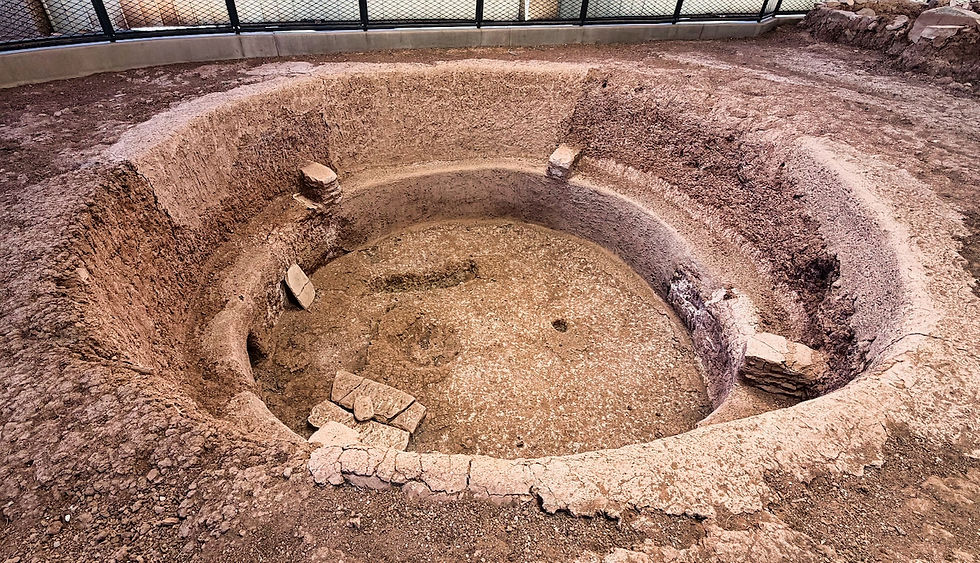
The Puebloans left the area between 1200 and 1300 A.D. and moved south along the Rio Grande River. More than 19 modern-day pueblos in Utah, Arizona, New Mexico, and Texas trace their lineage back to Mesa Verde.
Only in the last 200 years of occupation did some of the people build cliff dwellings into large alcoves. Archeologists have found some 500 or so cliff structures, but there are more than 5,000 sites up on top of the mesa.
We signed up for a couple of ranger-led tours. The first was to Cliff House, the most well-known of the cliff dwellings.

You hike down some steep stairs from the overlook.
On the way back up to the plateau, you need to climb up a couple of ladders and more steep stairs to reach the top.
Along the loop drive, you can view many other cliff structures.

You can also see the ruins of Sun Temple, a large structure built on top of the mesa. It was started shortly before the move to cliff dwellings began and was never completed.


Another day we drove to another part of the mesa...

...and visited Long House. It's almost as large as Cliff House but less visited. You hike about 0.75 miles from the parking area to meet up with a ranger...

...and then walk downhill to reach the dwellings. We actually liked Long House more because you can hike in and among the ruins - at Cliff House you just hike along the front.

Mesa Verde is an International Dark Sky Park, and we spent a couple of evenings sitting outside the RV and marveling at the stars and the Milky Way on moonless nights.

We also went to a ranger program near our campground and looked at several star clusters and distant galaxies through telescopes set up nearby.


We departed Mesa Verde on September 11 and crossed south into New Mexico - the final stage of our 2026 travels. More about our New Mexico adventures in our next blog post!


Comments